Basic Information
Observation Details
Observation Date:
February 7, 2023Submitted:
February 7, 2023Observer:
SAC - Savage, GensweinZone or Region:
Galena Summit and Eastern MtnsLocation:
Baker Ck-Brodie Gulch (6700-9300': most aspects over 8000', focused on SW-S-SE-E)Signs of Unstable Snow
Recent Avalanches?
None ObservedCracking?
None ExperiencedCollapsing?
IsolatedSnow Stability
Stability Rating:
GoodConfidence in Rating:
ModerateStability Trend:
Bottom Line
We didn't experience many signs of instability where we traveled, but we avoided wind-loaded avalanche terrain. The wind over the past week affected both middle and upper elevations and formed isolated slabs. Unless it snows much more than forecast, Wednesday's primary concern will be fresh wind slabs where we traveled. The multiple crusts+facets just below the current surface are ugly, but they need a slab above them to be a concern.
Advanced Information
Weather Summary
Cloud Cover:
OvercastTemperature:
near 30F parking lot, 20s F at middle elevationsWind:
Light , WNew/Recent Snowfall:
HST from last storm was about 5-8cmSkies began as PC/few and became overcast and eventually obscured by late afternoon. There is very little snow available for transport, and lots of evidence of previous wind transport at middle and upper elevations.
Snowpack Observations
HS=mostly 110-140cm on solars without significant wind-loading or scouring. Dramatic variability in the upper 15cm of the snowpack moving from shady (NW-N-NE) to E>SE>S/SW as well as moving from scoured to wind-affected to wind-loaded. A quick rundown, focusing on the upper 20cm in the snowpack:
NW-N-NE: Shady aspects were wind hammered (sastrugi, wind board, etc) for 50-100' vertical below exposed ridgelines 9000-9300'. We didn't directly observe the surface snow in more sheltered areas farther below the ridgelines, but the observations on E aspects lead me to believe some well-developed FC exist there.
E: A mix of "baby" wind slabs, wind-blown snow, and PP/FC above 10-20cm of well-developed FC. On some slopes, there was a thin razor crust at the top of the facets.
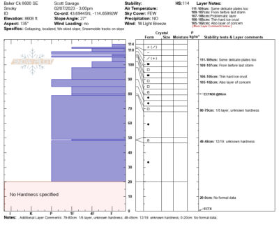
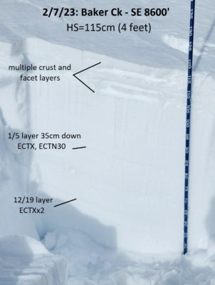
SE: The most concerning structure (if/when it gets loaded), and where we got one 5m collapse in the upper snowpack. The upper snowpack is an ugly mess. The surface stayed dry today. 1/5 and 12/19 were unreactive in ECT tests. See pit profile and photo.
S-SW: There was a fresh crust forming on the surface today. When previous crusts formed, free water formed perc columns below some of the crusts. Some of the FC in between crusts were moist. It's hard to say whether the crust+FC matrix will misbehave (where it has this "wetter" structure) when it eventually gets loaded.


Avalanche Problems
| Problem | Location | Distribution | Sensitivity | Size | Comments |
|---|---|---|---|---|---|
 Wind Slab
|
|
Unknown |
Layer Depth/Date: 15-40cm Comments: I shaded where I could see, and expect to encounter, wind slabs. There was a lot of wind blown snow and scouring at middle elevations below 9300', but no wind slabs. |
||
 Persistent Slab
|
|
Layer Depth/Date: 30-40cm Weak Layer(s): Jan 5, 2023 (SH) Comments: Shaded area indicates where we traveled and examined this weak layer. We did not observed any signs of instability with the 1/5 weak layer. It presents as FC on solars. |
The most significant avalanche problem in this area appears to be in the future with the weak snow (FC and SH on shady, FC and crusts on solars) formed in late January and early February.
Terrain Use
We avoided wind-loaded starting zones steeper than 35* and all starting zones steeper than 35* that were above consequential terrain.
