Basic Information
Observation Details
Observation Date:
December 20, 2020Submitted:
December 21, 2020Observer:
SAC - VandenBos (off duty)Zone or Region:
Banner SummitLocation:
Copper (6,700-7-600', primarily NE-N)Signs of Unstable Snow
Recent Avalanches?
None ObservedCracking?
WidespreadCollapsing?
WidespreadSnow Stability
Stability Rating:
PoorConfidence in Rating:
ModerateStability Trend:
WorseningBottom Line
New snow and warm temperatures are helping to establish a hefty slab on top of the weak snow underneath.
Media/Attachments

Advanced Information
Weather Summary
Cloud Cover:
ObscuredTemperature:
Near freezingWind:
ModerateSunday afternoon driving obs, Hailey to Stanley: Mostly cloudy to overcast in Hailey, driving north, precipitation began around Baker Creek, where it was snowing fat, heavy flakes around 1300. By Owl Creek precip had turned to rain with moderate intensity. Rain transitioning to wet snow around Galena Lodge (7,300'). Snowing S1 up and over the pass and down to Headwaters parking, where precip decreased in intensity a bit. Driving down the valley light, wet snowfall transitioned to drizzly rain around 6,600' or so. North of Stanley, rain/snow line was at around 6,500-6,600' all the way to sunset. Above that, dense, wet snow was falling.
Snowpack Observations
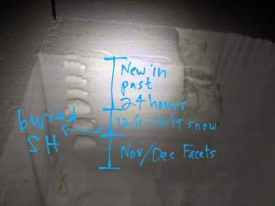
HS=100cm at 7,500'. 45cm new snow from past week, difficult to be certain how much was from past 24 hours, but appeared to be between 20 and 30cm. Several layers of buried SH down 40-45cm, likely buried 12/11, 12/13, and 12/15?
-ECTP 1, 10, and 11, all down 45cm
-CPST 17/100 and 20/100, both to END, down 45cm
-PST 15/100 and 17/100, both to END, down 45cm

Avalanche Problems
| Problem | Location | Distribution | Sensitivity | Size | Comments |
|---|---|---|---|---|---|
 Persistent Slab
|
|
Weak Layer(s):
Dec 11, 2020 (FCsf)
|
Terrain Use
Avoided avalanche terrain at all scales, large and small
