Basic Information
Observation Details
Observation Date:
February 24, 2021Submitted:
February 24, 2021Observer:
SAC - Ethan DavisZone or Region:
Galena Summit and Eastern MtnsLocation:
Gladiator Pk (SW-S-SE, 7,800-9,500')Signs of Unstable Snow
Recent Avalanches?
None ObservedCracking?
None ExperiencedCollapsing?
None ExperiencedSnow Stability
Stability Rating:
GoodConfidence in Rating:
ModerateStability Trend:
SteadyBottom Line
The potential for triggering a persistent slab remains. Weak layers in the middle of the snowpack produced propagating results in snowpack tests. Snow surfaces (within the upper 10-20 cm) are highly variable but all slopes (up to 9,500') have 1-2 crusts with associated small facets.
Media/Attachments
Advanced Information
Weather Summary
Cloud Cover:
Partly CloudyNew/Recent Snowfall:
10 cm since rain crust. 2 cm new during the day today.Variable cloudiness and locally gusty N/NE wind dictated by whether you were stuck in a squall band or not. Periods of snow amounting to ~1 in. Some sunny breaks, but I was mostly in the clouds.
Avalanche Observations
No new avalanches. Westernhome slides were reported yesterday.
Snowpack Observations
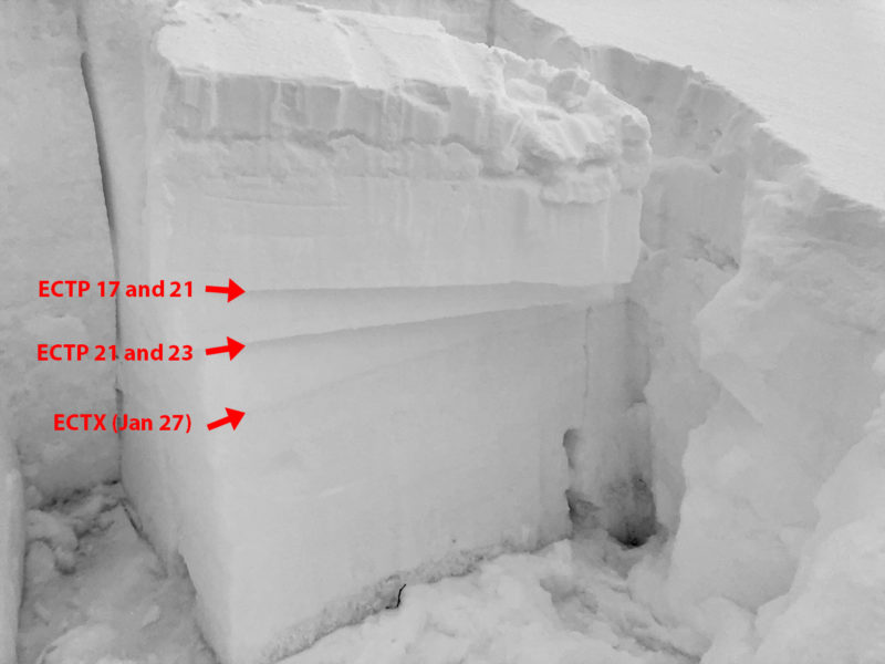
About 10 cm of new snow sat atop a rain crust to about 9,000'. Below the rain crust was another substantial melt-freeze crust, primarily on steeper souths and lower elevations. There was a lot of aspect, elevation, and slope angle dependency to these layers that will make things pretty hard to pin down moving forward. The double crust with facets between combo was particularly nasty looking.
The (1/27) and (12/11) layers didn't produce results, even with non-standard loading.
135* SE, 9,050', HS = 130 cm:
130-121 F, DF
121-120 K, Rain Crust
120-116 F, FC/DF
116-114 P, Sun Crust
114-95 4F
95-94 F, FC (2/19?) ---ECTPs
85-84 F, FC (2/11) ---ECTPs
84-74 P, Thin wind slab ---(1/27) @ 74 cm
74-45 4F, FC
45-30 4F-, DH ---(12/11)
30-0 1F-

Avalanche Problems
| Problem | Location | Distribution | Sensitivity | Size | Comments |
|---|---|---|---|---|---|
| None Specified |
|
Layer Depth/Date: 35 cm and 45 cm Comments: Shaded where directly observed. Facet layers producing ECTPs (2/11) and (2/19?) |
|||
 Persistent Slab
|
|
Layer Depth/Date: 100 cm Weak Layer(s): Dec 11, 2020 (FCsf) Comments: Obvious weaker snow near the ground with probing and in pit location. |
I observed fresh thin drifts up to 20 cm thick but did not encounter a wind slab problem in the terrain I traveled.
Terrain Use
I avoided avalanche terrain.

