Basic Information
Observation Details
Observation Date:
March 17, 2022Submitted:
March 17, 2022Observer:
SAC - Chris LundyZone or Region:
Sawtooth and Western Smoky MtnsLocation:
Near Williams Peak (6500-9400', SE-E-NE)Signs of Unstable Snow
Recent Avalanches?
YesCracking?
None ExperiencedCollapsing?
None ExperiencedSnow Stability
Stability Rating:
FairConfidence in Rating:
ModerateStability Trend:
ImprovingBottom Line
Primary objective today was looking for weak layers in the upper snowpack. Between yesterday's obs and triggered avalanche in Smiley Creek and today's obs, there seems to be enough evidence of a persistent slab problem even on wind-sheltered slopes - it's most pronounced on the facet/rain crust layer that's buried ~16" deep in this area. It still seems like a fairly isolated problem and may not last that long, but I would feel very uncomfortable on slopes over 35*.
Media/Attachments
Advanced Information
Weather Summary
Cloud Cover:
Partly CloudyWind:
CalmDay began nearly clear, with a few thin high clouds moving in mid-afternoon when I exited the field. Cloud cover continued to increase into the late afternoon. It felt quite warm in the sun, but still fairly cool in the shade.
Avalanche Observations
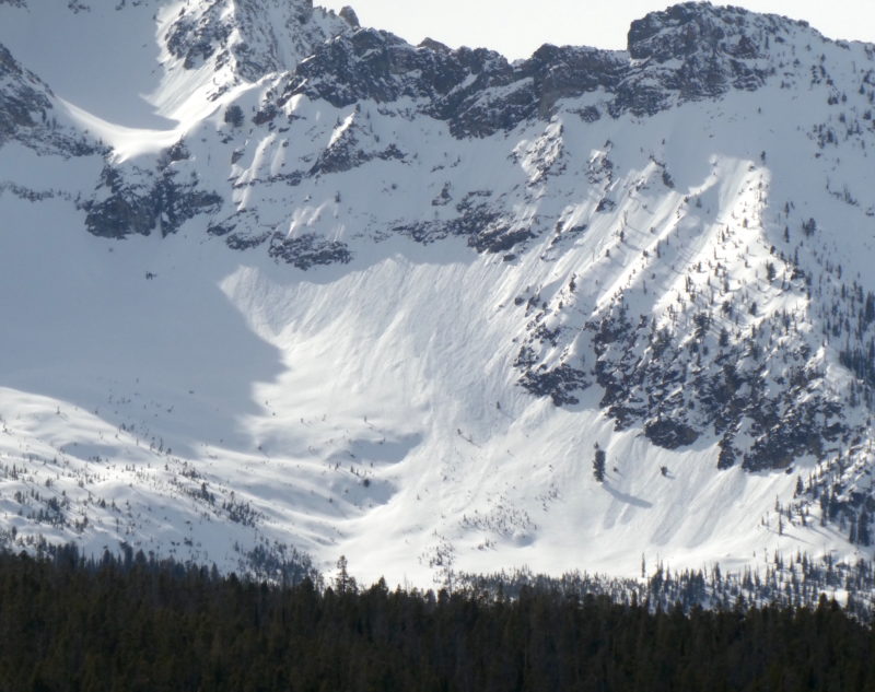
There were a few small D1 wet loose avalanches that occurred yesterday, and a few new ones occurred today. Nothing remarkable - see photo. Looking down "Marshall Slide" I could see some fresh and dry-looking D1 debris on the apron but couldn't tell where it came from. Perhaps a small wet loose coming from rocky terrain entrained some dryer or snow, or maybe it triggered a small slab. A photo I took when I got back to the Stanley RS was pretty dark, but I did not see a crown. There was a small D1 wind slab in upper Meadow Bowl - Ben saw this yesterday. I did not see any other slab avalanches.
Snowpack Observations
Recent HST sitting on the rain crust increased from 12cm at 7600' to 40cm + at 9000'. Primary goal was to look for weak layers in the upper 1m of the snowpack, especially adjacent to the rain crust - the layer responsible for the triggered slide in Smiley Cr yesterday.
@8300', E: 40cm of snow atop the 3/8 rain crust. There were a few soft crusts in this snow from the warm storms. The rain crust was 6cm of K snow - I had a difficult time cutting an ECT. This crust may be thicker as it was likely subject to warming temps and sun after the rain event. There was a 10cm layer of F FC down 55cm - likely the 1/20 layer. I did not get any test results on the rain crust. I got an ECTP17 in the 1/20 FC, but it seems like the thick rain crust is likely having a "bridging" effect. It would have been interesting to see a more shady aspect at this elevation.
@8700', ENE: 43cm of snow atop the rain crust. No crusts in this recent snow, the top half was F increasing to 4F above the rain crust. ECTP22 and 23 on the rain crust (see video attached). I did not see any particularly weak snow below the rain crust, showing how variable the 1/20 layer is. This slope was relatively wind-sheltered but was getting into more open mid-elevation terrain. Stepping above the pit and my approach skin track, I got a crack extending out about 10'.
I saw relatively minimal wind loading on "Skiers Summit". I did some ski cutting/stomping on the descent and didn't experience any cracking. Looking into the adjacent alpine basins, there was not a ton of wind-effect.
Avalanche Problems
| Problem | Location | Distribution | Sensitivity | Size | Comments |
|---|---|---|---|---|---|
 Persistent Slab
|
|
Layer Depth/Date: 40cm Weak Layer(s): Mar 8, 2022 (FC) Comments: Rose indicates where I observed the problem. Distribution is still a bit of an unknown. The 3/8 FC/MFcr seems to be the primary weak layer, but the 1/20 layer may be lurking about as well. |
|||
 Wet Loose
|
|
My guess is that any wind slab that was triggered would involve a persistent weak layer.
Terrain Use
I avoided terrain steeper than the low 30s


