Basic Information
Observation Details
Observation Date:
December 16, 2020Submitted:
December 16, 2020Observer:
SAC - Ethan DavisZone or Region:
Soldier and Wood River Valley MtnsLocation:
Dollarhide Mountain (Variety of aspects, 7,000-9,100')Signs of Unstable Snow
Recent Avalanches?
None ObservedCracking?
IsolatedCollapsing?
None ExperiencedBottom Line
There was no appreciable avalanche hazard in the terrain I traveled today. The snowpack is mostly weak and thin but lacks a cohesive slab to create any real problems. I did find a few small, reactive drifts along ridgelines. If tonight's storm packs a little more punch we will likely have a wind slab problem in exposed terrain.
Short video from today: https://www.instagram.com/p/CI4A3e9FrF1/
Media/Attachments


Advanced Information
Weather Summary
Cloud Cover:
Mostly SunnyTemperature:
29FWind:
Light , WA healthy looking cloud bank was pushing into the Soldiers from the west. Otherwise there were very few clouds in the sky.
Snowpack Observations
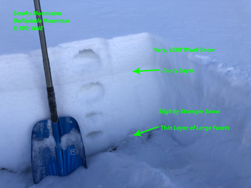
In a nutshell, the snowpack was thin (1-2' deep) and weak. Mid and upper elevation snow was noticeably weaker than what I found last week in the Soldiers in similar locations. There were one or two crusts on sunnier slopes (wrapping to W and E) and a bit of somewhat-supportable snow (4F..) near the ground in deeper, north-facing terrain. Beyond that, it was a sea of dry facets that were pouring out of my pit wall when performing hand harness tests...
2-3" of recent snow since Sunday capped surface hoar from the dry spell, and another layer of small surface hoar sprang up last night. This thin layer of surface hoar and recent faceted snow sits on a crust in some locations and looks like it could be a particularly touchy interface moving forward.
Overall snow cover and depth increased from the trailhead in Warm Springs to Placer and then again, noticeably as I approached Dollarhide Summit.

Terrain Use
My only concerns were thin snow cover hazards.
