Basic Information
Observation Details
Observation Date:
January 13, 2022Submitted:
January 13, 2022Observer:
SAC - Bret RasmussenZone or Region:
Island ParkLocation:
Lion Head benchSigns of Unstable Snow
Recent Avalanches?
None ObservedCracking?
IsolatedCollapsing?
None ExperiencedSnow Stability
Stability Rating:
GoodConfidence in Rating:
HighStability Trend:
ImprovingBottom Line
I feel like we are in great shape on Lion Head. The snowpack is quite solid. We saw great results from our field tests today. The trending warmer weather is a bonus to helping solidify the snowpack even more. I saw a few isolated deeper wind slabs that deserve respect. The weak layer near the surface could become a problem after the next storm cycle, but for now it is not supporting enough weight to fail in a big way. The facet layer at the bottom of the snowpack is healing nicely where the snow is deep. I warn that in shallower snowpack this might not be the case, with the recent high winds a lot of snow has been removed from certain areas and deposited in others. Be on the lookout for potential isolated hot spots!!
Advanced Information
Weather Summary
Cloud Cover:
OvercastTemperature:
29fWind:
Light , WNew/Recent Snowfall:
NATrending warmer weather. Localized blowing snow. Most of the snow available for transport has already been transported!!
Snowpack Observations
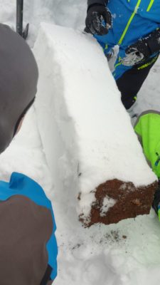
Results of snow pit instability tests at 8500 feet, 38 degrees NE aspect, 19 degree slope. HS 195cm. CTEQ1@185cm, CTHQ1@167cm, CTHQ1@162cm. ECTP10@180cm. DTN. The Compression test shows that we have multiple layers of snow, while the extended column test shows the layers are bonded well enough that we get only one failure with propagation. With a deep tap test the suspect PWL at the bottom of the snowpack did not fail. It sheared off at the ground. (see photo attached) The facets at the bottom of the snowpack are turning into rounds and starting to bond. Even though I saw a 4 finger density in this layer it still supported the snow above it. The weakest layer is found near the top of the snowpack about 15cm thick with about 15cm wind slab on top of it made up of fragmented precipitation particles with fist hardness. I observed some shallow cracking caused by a sled ski or track stressing the surface wind slab.


