Basic Information
Observation Details
Observation Date:
March 8, 2022Submitted:
March 8, 2022Observer:
SAC - Scott SavageZone or Region:
Galena Summit and Eastern MtnsLocation:
Titus ridge (8700-9600': W,NW,NE,E,SE)Signs of Unstable Snow
Recent Avalanches?
None ObservedCracking?
IsolatedCollapsing?
None ExperiencedSnow Stability
Stability Rating:
Very GoodConfidence in Rating:
ModerateStability Trend:
SteadyBottom Line
No obvious avalanche problems existed where I traveled (middle elevations) this afternoon...but there was enough wind to form small, thin wind slabs at upper elevations. And, there might be some isolated slopes where the fresh wind slabs are stressing weak snow in the upper snowpack enough to make human-triggered avalanches possible. I'd be surprised to hear about someone triggering a large slab avalanche on weak faceted layers in the upper foot of the snowpack in this area, but it may be within the realm of possibility. Unfortunately, the weak layer and slab distributions are extremely variable over relatively small changes in aspect and/or elevation; if/when we get a "real" storm, evaluating stability will become difficult with a lot of uncertainty in the equation (applies to where I traveled, 8700-9600' near Titus).
Media/Attachments
Advanced Information
Weather Summary
Cloud Cover:
Mostly CloudyTemperature:
Teens F above 9000'Wind:
Moderate , NWNew/Recent Snowfall:
HN/HST=1cm at Galena Summit (8700'), 2-3cm 9300-9600'Squally weather with the Sawtooths, western Smokys, White Clouds socked in and snowing all day, valley locations partly cloudy, and places like Titus in the middle (some sun, some light snow, mixed bag). Appeared to be a strong orographic component to today's snowfall/weather. Winds were light to moderate and gusty at 9400-9600', audibly strong and gusty in nearby alpine terrain. Winds were moving the little new snow available for transport.
Snowpack Observations
See snowpack video link below.
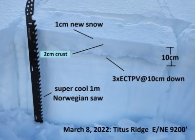
I focused on the upper 40cm (16") of the snowpack. It was as a complex mess on shady (E-NE-N-NW) aspects from 8700-9600'. 1-3cm of new snow (DF/PP) on top of a 1-3cm thick crust up to 9200-9400'. The crust thinned and went away by 9400' on shady aspects. Below the crust, the snowpack was extremely variable (30cm of F FC to a 30cm slab averaging 1F). Summary: the upper pack mixture of facets, crusts, melt-freeze grains, and a little SH and other forms varies dramatically as you move up, down, and around the compass. When/if we get a decent load, it looks like it could be a classic Goldilocks scenario: just the right combination of weak layer+slab+crust strength (where they exist) may cause issues. Figuring out where that perfect combination exists will be difficult unless it snows a lot and makes everything unstable.
I primarily looked for 2 scenarios today: the weakest possible snowpack going forward, and anywhere there may be a chance of triggering avalanches today (weak layer + slab with about 2" of SWE above it).
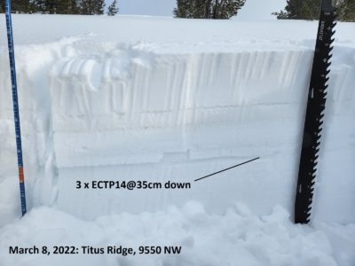
9550 NW (see photo): HS=190cm, deep area that receives wind transport: This location had an abnormally thick+dense slab above the various drought weak layers and interfaces (abnormal slab for this zone/area). Several weak layers/interfaces in the upper pack with some SH shards in most of them. 3 times ECTP14 at the 1/20 layer. Would be spooky if this snowpack setup existed in much avalanche terrain.
9200 ENE (see photo): HS=130cm: This crust+FC set up was "perfect" from about 9100-9250'; above that, the crust thinned and the FC were not as well developed...below that, the crust hardened and thickened and the FC had more water in them at some point (not as weak). 3xECTPV at 10 cm down, unable to isolate a column every time. This snowpack will be terrifying with a quick inch of water on top of it. Good thing every slope doesn't like this thin elevation band.


Avalanche Problems
No obvious problems where I traveled. Possible minor wind slab problem at upper elevations. There are persistent weak layers on some aspects and elevations, but none of the PWL were consistently loaded enough (slope to slope over space) to be a problem.
Terrain Use
I planned to avoid large or consequential avalanche paths that were wind-loaded. I did not encounter any such places. I avoided all recently wind-loaded NW-N-NE terrain near/over 38* (I was traveling solo).

