Basic Information
Observation Details
Observation Date:
April 15, 2022Submitted:
April 15, 2022Observer:
SAC - Scott SavageZone or Region:
Galena Summit and Eastern MtnsLocation:
Galena Summit - Cross area (S-SE-E-NE-N-NW: 8300-9200')Signs of Unstable Snow
Recent Avalanches?
None ObservedCracking?
IsolatedCollapsing?
None ExperiencedSnow Stability
Stability Rating:
GoodConfidence in Rating:
ModerateStability Trend:
Bottom Line
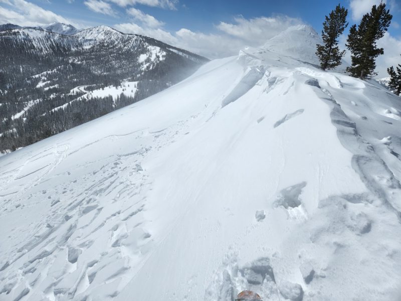
I found isolated wind slabs right at exposed ridgelines near 9200', but they did not extend far enough below the ridges to be a hazard in middle elevation terrain. With significant previous and ongoing wind transport, alpine terrain in this area is likely far more dangerous. Very steep, sunnier aspects in sheltered terrain were turning to mush and could have become a problem this afternoon after I left. For Saturday's storm, there are going to be 2 potential weak layers in the upper snowpack on sunnier aspects in this area: crusts and facets that formed at/near the surface today, and thin crusts and facets that formed earlier this week (about half way from today's surface to the old, hard crust).
Media/Attachments
Advanced Information
Weather Summary
Cloud Cover:
Partly CloudyTemperature:
Teens and 20s FWind:
Moderate , WNew/Recent Snowfall:
HST=25cm (10") at 8300' at the road and 40cm (16") on shady terrain 8800-9200'Cloud cover decreased from 11-3:00. Gusty, moderate W winds were moving snow all day in exposed middle elevation terrain. Today's sun is sprobably limiting the snow available for transport on solar aspects going forward, but there is plenty of snow available on shadier slopes and at upper elevations.
Snowpack Observations
Storm snow/old interface was not very sensitive where I traveled (mostly NE-E-SE-S, a little bit on N-NW). No obvious mid-storm layers in shady terrain.
Surfaces: I observed a crust and FC combo forming on NE-E-SE-S below 8700' and on E-SE from 8800-9100'. No crusts forming in the windy zone above 9100'. I expect the surface crusts to form on SW-W-NW below 8700' and S-SW-W from 8800-9100' where I was today. More northerly slopes stayed dry.
Upper snowpack below surface: Ski penetration = 10cm on solars and 20-30cm on shady, staying above the old hard crust. Boot penetration = to the old crust (15-20cm on solars). The sun made the upper 10cm moist on solars/sunny slopes. There was a thin crust+FC combo buried about half way down in the storm snow, likely from Tues or Wed. The moist surface snow wanted to move on the Tues/Wed interface on very steep slopes and cracked a few feet out in front of me a couple times.
No observations below the most recent, stout ice crust.
Avalanche Problems
| Problem | Location | Distribution | Sensitivity | Size | Comments |
|---|---|---|---|---|---|
 Wind Slab
|
|
Layer Depth/Date: 20-40cm Comments: Location rose shows where I observed the problem. I ski cut one baby wind slab, see photo. Wind slabs isolated to right beneath prominent middle elevation ridgelines near 9200' where I traveled. Up to 2 ft of new cornice growth, but mostly less than a foot. Alpine terrain would be a different beast (more dangerous). |
|||
 Wet Loose
|
|
Layer Depth/Date: 10-15cm Comments: Location rose shows where I traveled and would have expected wet loose concerns in the perfect terrain (very steep + sheltered + SE-S-SW). On slopes with all of those characteristics, you may have been able to trigger small wet loose slides this afternoon. That terrain did not exist where I traveled. |
Terrain Use
I planned to avoid large, wind-loaded avalanche starting zones and hot, sunny, wind-sheltered avalanche paths with terrain traps beneath them. I did not see anything to make me change my mind.

